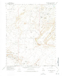
1962 Map of White Mesa Village
USGS Topo · Published 1975About this map
The Aneth Oil Field dominates this high-desert landscape within the Navajo Indian Reservation, reflecting the mid-century petroleum expansion in the Four Corners region. Industrial infrastructure is etched across the terrain, including the Red Mesa Pumping Station and numerous Drill Holes, alongside specialized settlements like White Rock Village and White Mesa Village. The map captures a moment when remote worker housing and supply centers like Aztec Camp and Continental Camp were active hubs for the industry. Geologic landmarks such as Casa Del Eco Mesa, Hogan Mesa, and Lone Mountain provide a stark contrast to the network of Jeep Trails and Airstrips used to navigate the canyons and washes of San Juan Co.
Find a feature on this map
47 named features on this map. Tap any name to fly to it.
Don’t see what you’re looking for? This feature index may not catch every label — zoom into the map to look around manually.
Map Details
Editions of this 1962 White Mesa Village Map
2 editions found
Other maps of this area

1886 · Abajo
USGS Topo · 1:250,000

1892 · Abajo
USGS Topo · 1:250,000

1892 · Canyon De Chelly
USGS Topo · 1:250,000

1893 · Abajo
USGS Topo · 1:250,000

1953 · Dinne Mesa NW
USGS Topo · 1:24,000

1953 · Pastora Peak NW
USGS Topo · 1:24,000

1953 · Dinne Mesa NE
USGS Topo · 1:24,000

1953 · Pastora Peak
USGS Topo · 1:62,500

1953 · Toh-Atin Mesa
USGS Topo · 1:62,500

1954 · Shiprock
USGS Topo · 1:250,000
Featured Places
- Shiprock Agency
- White Rock Curve Village, Shiprock Agency
- Red Lake Village, Shiprock Agency
- White Mesa Village, Shiprock Agency
- San Juan County, UT