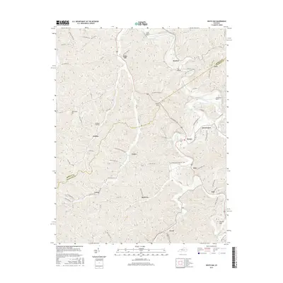
2016 Map of White Oak
USGS Topo · Published 2016About this map
The boundary between Morgan and Magoffin counties bisects a landscape defined by sharp ridges and deep hollows in eastern Kentucky. Small settlements and family-named landmarks are scattered throughout the terrain, following the winding paths of Jones Creek, Grape Creek, and Pricy Creek. Communities such as White Oak, Bloomington, and Wonnie serve as central points in a network of roads that navigate the complex topography, including State Hwy 1081 and several local routes like Carpenter Bend Rd.
Find a feature on this map
69 named features on this map. Tap any name to fly to it.
Don’t see what you’re looking for? This feature index may not catch every label — zoom into the map to look around manually.
Map Details
Editions of this 2016 White Oak Map
This is the sole edition of this map. No revisions or reprints were ever made.
Other maps of this area

1889 · Salyersville
USGS Topo · 1:125,000

1891 · Salyersville
USGS Topo · 1:125,000

1899 · Salyersville
USGS Topo · 1:125,000

1950 · Lenox
USGS Topo · 1:24,000

1951 · Cannel City
USGS Topo · 1:24,000

1951 · White Oak
USGS Topo · 1:24,000
1951 · Dingus
USGS Topo · 1:24,000
1951 · Salyersville North
USGS Topo · 1:24,000
1951 · Lenox
USGS Topo · 1:24,000

1951 · Seitz
USGS Topo · 1:24,000