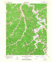
1965 Map of White Oak
USGS Topo · Published 1967About this map
The Licking River carves a deep path through the borderlands of Magoffin and Morgan Counties, defining a landscape of sharp ridges and narrow hollows. In the mid-1960s, small communities like Bloomington, White Oak, and Wonnie anchor the rural economy, the latter home to the Radio Tower (WRLS-Wonnie). Local education is centered at the Hensley Sch near the river's bend. The terrain is deeply marked by industry and infrastructure, visible in the numerous Strip Mines and the presence of a significant pipeline corridor crossing through Orchard Hollow. Along the southern reaches of the map, the Mtn Pkwy begins to influence local travel, while traditional life continues along the banks of the Middle Fork and Settlement Branch. Genealogists may find value in the various family cemeteries and small settlements like Bethanna, Elsie, and Kernie that dot the landscape.
Find a feature on this map
78 named features on this map. Tap any name to fly to it.
Don’t see what you’re looking for? This feature index may not catch every label — zoom into the map to look around manually.
Map Details
Editions of this 1965 White Oak Map
This is the sole edition of this map. No revisions or reprints were ever made.
Other maps of this area

1889 · Salyersville
USGS Topo · 1:125,000

1891 · Salyersville
USGS Topo · 1:125,000

1899 · Salyersville
USGS Topo · 1:125,000

1950 · Lenox
USGS Topo · 1:24,000

1951 · Cannel City
USGS Topo · 1:24,000

1951 · White Oak
USGS Topo · 1:24,000
1951 · Dingus
USGS Topo · 1:24,000
1951 · Salyersville North
USGS Topo · 1:24,000
1951 · Lenox
USGS Topo · 1:24,000

1951 · Seitz
USGS Topo · 1:24,000