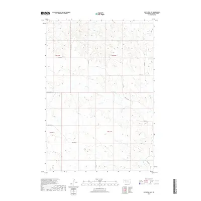
2017 Map of White Owl NW
USGS Topo · Published 2017About this map
Red Owl Cr and its tributaries carve a network of drainages across this section of the western South Dakota plains. The landscape is defined by the hydrologic patterns of Elm Cr in the north and the upper reaches of White Owl Cr in the southeast. While devoid of dense settlements, the map reveals a system of rural connectivity through local routes like Spring Creek Rd, Green Valley Rd, and Pleasant View Rd. This 2017 data captures the modern configuration of Meade County's open rangeland, where the placement of Lang Rd and Tidewater Rd provides spatial context for ranching operations and property divisions in townships t9n r13e through t8n r14e.
Find a feature on this map
17 named features on this map. Tap any name to fly to it.
Don’t see what you’re looking for? This feature index may not catch every label — zoom into the map to look around manually.
Map Details
Editions of this 2017 White Owl NW Map
This is the sole edition of this map. No revisions or reprints were ever made.
Other maps of this area

1953 · Rapid City
USGS Topo · 1:250,000

1957 · Rapid City
USGS Topo · 1:250,000

1959 · Enning
USGS Topo · 1:24,000

1959 · Redowl
USGS Topo · 1:24,000

1983 · Whiteman Owl NW
USGS Topo · 1:24,000

1983 · Opal West SE
USGS Topo · 1:24,000

1983 · Whiteman Owl
USGS Topo · 1:24,000
1983 · Whiteman Owl SE
USGS Topo · 1:24,000

1983 · Opal East SW
USGS Topo · 1:24,000

1983 · Marcus
USGS Topo · 1:24,000