1959 Map of Enning
USGS Topo · Published 1960About this map
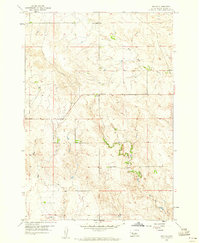
Enning sits at the center of this 1950s South Dakota landscape, serving as a focal point for the surrounding rural ranching and farming community. The terrain is defined by the drainage systems of White Owl Creek and its tributary, East Fork White Owl Creek, which cut through the undulating plains in the north, while Bull Creek dominates the southwestern corner. One of the few marked civic structures is the Divide Sch, positioned along the northern ridge line near the divide between watersheds. This survey captures the sparse settlement pattern characteristic of Meade County during this era, where infrastructure was limited to section-line roads, a scattered Gravel Pit, and isolated schools serving the local population. The map provides a clear record of the area's hydrology and land divisions just before the turn of the decade.
Find a feature on this map
6 named features on this map. Tap any name to fly to it.
Don’t see what you’re looking for? This feature index may not catch every label — zoom into the map to look around manually.
Map Details
Editions of this 1959 Enning Map
2 editions found

Other maps of this area

1953 · Rapid City
USGS Topo · 1:250,000

1954 · Dalzell NW
USGS Topo · 1:24,000
1954 · Haydraw
USGS Topo · 1:24,000

1954 · Boneita Springs
USGS Topo · 1:24,000

1957 · Rapid City
USGS Topo · 1:250,000

1959 · Redowl
USGS Topo · 1:24,000

1959 · Stoneville
USGS Topo · 1:24,000

1959 · Union Center
USGS Topo · 1:24,000

1983 · Whiteman Owl NW
USGS Topo · 1:24,000

1983 · Whiteman Owl
USGS Topo · 1:24,000