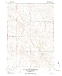
1959 Map of Enning
USGS Topo · Published 1983About this map
Enning serves as the focal point for this rural expanse in Meade County, where the topography transitions between high divides and seasonal watercourses. The landscape is defined by the headwaters of several drainages, including White Owl Creek in the northeast and Bull Creek to the southwest. This map records the placement of essential community structures that once anchored the area's social life, such as the Divide Sch situated near the northern ridge. The survey provides a clear view of the section lines and township boundaries, including the meeting of T. 8 N. T. 7 N. and T. 7 N. T. 6 N., which guided the settlement and agricultural parceling of this portion of South Dakota. An isolated Gravel Pit near East Killdeer Creek reflects the local resource extraction necessary for road maintenance and regional development during the mid-century period.
Find a feature on this map
9 named features on this map. Tap any name to fly to it.
Don’t see what you’re looking for? This feature index may not catch every label — zoom into the map to look around manually.
Map Details
Editions of this 1959 Enning Map
2 editions found
Other maps of this area

1953 · Rapid City
USGS Topo · 1:250,000

1954 · Dalzell NW
USGS Topo · 1:24,000

1954 · Haydraw
USGS Topo · 1:24,000

1954 · Boneita Springs
USGS Topo · 1:24,000

1957 · Rapid City
USGS Topo · 1:250,000

1959 · Enning
USGS Topo · 1:24,000

1959 · Redowl
USGS Topo · 1:24,000

1959 · Stoneville
USGS Topo · 1:24,000

1959 · Union Center
USGS Topo · 1:24,000

1983 · Whiteman Owl NW
USGS Topo · 1:24,000