
1954 Map of Dalzell NW
USGS Topo · Published 1956About this map
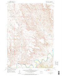
The Belle Fourche River meanders across the southern portion of this landscape, its path defined by a Levee and various benchmarks like XBM 2130. This mid-century survey, conducted as part of the Department of the Interior program for the development of the Missouri River Basin, reveals a sparse ranching and farming territory where water sources and elevation markers dictate human activity. The presence of the Cowen Sch in the northwest corner suggests a localized center for a rural community, while the drainage network including Killdeer Creek, Badlands Creek, and East Creek carves through the undulating terrain. A simple Ford provides a crossing point over the river, emphasizing the reliance on basic infrastructure in this part of Meade County during the 1950s.
Find a feature on this map
14 named features on this map. Tap any name to fly to it.
Don’t see what you’re looking for? This feature index may not catch every label — zoom into the map to look around manually.
Map Details
Editions of this 1954 Dalzell NW Map
2 editions found
Other maps of this area

1953 · Rapid City
USGS Topo · 1:250,000

1954 · Dalzell SE
USGS Topo · 1:24,000

1954 · Dalzell
USGS Topo · 1:24,000

1954 · Dalzell NE
USGS Topo · 1:24,000

1954 · Elm Springs
USGS Topo · 1:24,000

1954 · Boneita Springs
USGS Topo · 1:24,000

1957 · Rapid City
USGS Topo · 1:250,000

1959 · Enning
USGS Topo · 1:24,000

1983 · Whiteman Owl
USGS Topo · 1:24,000
1983 · Whiteman Owl SE
USGS Topo · 1:24,000