
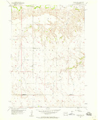
1954 Map of Dalzell
USGS Topo · Published 1956About this map
The Belle Fourche River winds through the northern portion of this Meade County landscape, defining a terrain shaped by drainage patterns like Bradley Draw and Trussman Draw. During the mid-1950s, this area of South Dakota remained a sparsely settled ranching and farming region, as evidenced by the rural schoolhouses that served the local families. The tiny settlement of Dalzell sits near the eastern edge, while the interior is marked by the Linn Sch and Bradley Sch. These small, localized landmarks are essential for tracing mid-century homesteads and the distribution of residents across the plains before the consolidation of rural school districts. To the south, the Sand Springs Draw cuts through the high ground, providing a detailed look at the water sources and topographical features like Shepherd Flat that dictated the layout of local roads and property boundaries.
Find a feature on this map
8 named features on this map. Tap any name to fly to it.
Don’t see what you’re looking for? This feature index may not catch every label — zoom into the map to look around manually.
Map Details
Editions of this 1954 Dalzell Map
This is the sole edition of this map. No revisions or reprints were ever made.
Other maps of this area

1953 · Rapid City
USGS Topo · 1:250,000

1954 · Dalzell SE
USGS Topo · 1:24,000

1954 · Dalzell NW
USGS Topo · 1:24,000

1954 · Wasta NE
USGS Topo · 1:24,000

1954 · Wasta NW
USGS Topo · 1:24,000

1954 · Dalzell NE
USGS Topo · 1:24,000

1954 · Elm Springs
USGS Topo · 1:24,000

1954 · Boneita Springs
USGS Topo · 1:24,000

1957 · Rapid City
USGS Topo · 1:250,000
1957 · Owanka NE
USGS Topo · 1:24,000