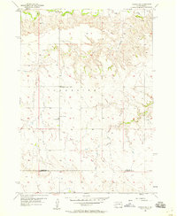
1957 Map of Owanka NE
USGS Topo · Published 1958About this map
Lakeside terrain dominates this mid-century landscape where the rural community structures of western South Dakota are preserved in detail. The map highlights the localized social centers of the era, including the St Margarets Ch and Lakeside Ch, which served the surrounding ranching and farming families. Educational history is anchored by the presence of School No 20, providing a specific point of interest for genealogists tracing ancestral homesteads in this portion of the Great Plains.
Find a feature on this map
8 named features on this map. Tap any name to fly to it.
Don’t see what you’re looking for? This feature index may not catch every label — zoom into the map to look around manually.
Map Details
Editions of this 1957 Owanka NE Map
This is the sole edition of this map. No revisions or reprints were ever made.
Other maps of this area

1953 · Rapid City
USGS Topo · 1:250,000

1954 · Elm Springs SW
USGS Topo · 1:24,000

1954 · Dalzell
USGS Topo · 1:24,000

1954 · Wasta
USGS Topo · 1:24,000

1954 · Owanka
USGS Topo · 1:24,000

1954 · Wasta NW
USGS Topo · 1:24,000

1954 · Elm Springs
USGS Topo · 1:24,000

1957 · Rapid City
USGS Topo · 1:250,000
1957 · Owanka NW
USGS Topo · 1:24,000
1957 · Owanka SW
USGS Topo · 1:24,000