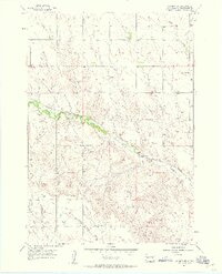
1957 Map of Owanka SW
USGS Topo · Published 1958About this map
The Chicago and North Western railroad corridor anchors this mid-century portrait of Pennington County, running alongside the winding course of Boxelder Creek. This prairie landscape is defined by its drainage patterns, where Patterson Creek and long topographic depressions like Dipping Vat Draw and Brown Draw shape the ranching country. The presence of rural schoolhouses, including Harmony Sch in the northeast and Pleasant Hill Sch further south, highlights the localized community structure of the late 1950s. Surveyed just before significant shifts in rural infrastructure, the map details a network of unimproved roads and light-duty trails that connect these isolated landmarks across the undulating South Dakota terrain.
Find a feature on this map
7 named features on this map. Tap any name to fly to it.
Don’t see what you’re looking for? This feature index may not catch every label — zoom into the map to look around manually.
Map Details
Editions of this 1957 Owanka SW Map
2 editions found
Other maps of this area

1953 · Viewfield
USGS Topo · 1:24,000

1953 · New Underwood
USGS Topo · 1:24,000

1953 · Caputa NE
USGS Topo · 1:24,000

1953 · Rapid City
USGS Topo · 1:250,000

1954 · Owanka
USGS Topo · 1:24,000

1954 · Creston
USGS Topo · 1:24,000

1954 · Brennan Flat
USGS Topo · 1:24,000

1955 · Hot Springs
USGS Topo · 1:250,000

1957 · Rapid City
USGS Topo · 1:250,000
1957 · Owanka NE
USGS Topo · 1:24,000