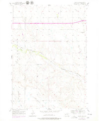
1957 Map of Owanka SW
USGS Topo · Published 1979About this map
Boxelder Creek carves a winding path through this western South Dakota landscape, defining the topography of the Underwood area. The Chicago and North Western railroad tracks run parallel to the creek bed, illustrating the historical importance of water-level routes for mid-century transportation. Rural life is anchored by several small schoolhouses, including Harmony Sch in the northeast and Pleasant Hill Sch to the west, which served as local landmarks for families scattered across the prairie. The map captures a moment of infrastructure development with the presence of Interstate 90 and highways 14 16 90, showing the transition from early rail dominance to the modern interstate system. Local drainage features like Dipping Vat Draw and Day Brown Draw reflect the naming conventions of the region's ranching history and local geography.
Find a feature on this map
13 named features on this map. Tap any name to fly to it.
Don’t see what you’re looking for? This feature index may not catch every label — zoom into the map to look around manually.
Map Details
Editions of this 1957 Owanka SW Map
2 editions found
Other maps of this area

1953 · Viewfield
USGS Topo · 1:24,000

1953 · New Underwood
USGS Topo · 1:24,000

1953 · Caputa NE
USGS Topo · 1:24,000

1953 · Rapid City
USGS Topo · 1:250,000

1954 · Owanka
USGS Topo · 1:24,000

1954 · Creston
USGS Topo · 1:24,000

1954 · Brennan Flat
USGS Topo · 1:24,000

1955 · Hot Springs
USGS Topo · 1:250,000

1957 · Rapid City
USGS Topo · 1:250,000
1957 · Owanka NE
USGS Topo · 1:24,000