
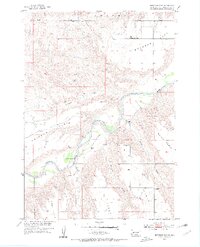
1954 Map of Brennan Flat
USGS Topo · Published 1956About this map
The Cheyenne River carves a deep path through western South Dakota, defining the landscape of this 1954 survey for the Missouri River Basin development program. The topography is dominated by extensive plateaus known locally as tables, including Quinn Table, Scene Table, and Kube Table, which overlook the river valley and its surrounding flats. These elevated plains represent the distinct geological character of Pennington County, where drainage systems like Beaver Creek and Farnum Draw have eroded the land into a complex network of ridges and draws.
Find a feature on this map
13 named features on this map. Tap any name to fly to it.
Don’t see what you’re looking for? This feature index may not catch every label — zoom into the map to look around manually.
Map Details
Editions of this 1954 Brennan Flat Map
2 editions found
Other maps of this area

1953 · Rapid City
USGS Topo · 1:250,000

1954 · Scenic
USGS Topo · 1:24,000

1954 · Wasta
USGS Topo · 1:24,000

1954 · Owanka
USGS Topo · 1:24,000

1954 · Creston
USGS Topo · 1:24,000

1954 · Scenic SW
USGS Topo · 1:24,000

1954 · Quinn Table
USGS Topo · 1:24,000

1955 · Hot Springs
USGS Topo · 1:250,000

1957 · Rapid City
USGS Topo · 1:250,000
1957 · Owanka SW
USGS Topo · 1:24,000