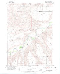
1954 Map of Brennan Flat
USGS Topo · Published 1956About this map
The Cheyenne River carves a deep path through Pennington County on this mid-century survey, creating a dramatic landscape of elevated plateaus and erosional draws. The geography is defined by prominent "tables"—flat-topped landforms that rise above the river valley—including Quinn Table, Kube Table, and Scenic Table. These high benches are separated by significant drainages like Timber Draw and Farnum Draw, which channel runoff toward the main river.
Find a feature on this map
15 named features on this map. Tap any name to fly to it.
Don’t see what you’re looking for? This feature index may not catch every label — zoom into the map to look around manually.
Map Details
Editions of this 1954 Brennan Flat Map
2 editions found
Other maps of this area

1953 · Rapid City
USGS Topo · 1:250,000

1954 · Scenic
USGS Topo · 1:24,000

1954 · Wasta
USGS Topo · 1:24,000

1954 · Owanka
USGS Topo · 1:24,000

1954 · Creston
USGS Topo · 1:24,000

1954 · Scenic SW
USGS Topo · 1:24,000

1954 · Brennan Flat
USGS Topo · 1:24,000

1954 · Quinn Table
USGS Topo · 1:24,000

1955 · Hot Springs
USGS Topo · 1:250,000

1957 · Rapid City
USGS Topo · 1:250,000