
1954 Map of Scenic SW
USGS Topo · Published 1956About this map
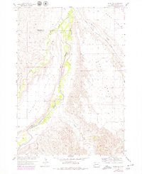
The Cheyenne River winds through this mid-century landscape, carving a deep path between the elevated plateaus of Kube Table and Hart Table. This area, situated along the border of Pennington and Custer counties, illustrates the high-plains topography of western South Dakota before modern land-use changes. The presence of the Hart Table Sch serves as a marker of the rural community that once centered around these tablelands.
Find a feature on this map
15 named features on this map. Tap any name to fly to it.
Don’t see what you’re looking for? This feature index may not catch every label — zoom into the map to look around manually.
Map Details
Editions of this 1954 Scenic SW Map
2 editions found
Other maps of this area

1950 · Sheep Mountain Table
USGS Topo · 1:24,000

1951 · Heutmacher Table
USGS Topo · 1:24,000

1951 · Red Shirt NE
USGS Topo · 1:24,000

1953 · Folsom
USGS Topo · 1:24,000

1953 · Caputa NE
USGS Topo · 1:24,000

1954 · Scenic
USGS Topo · 1:24,000

1954 · Creston
USGS Topo · 1:24,000

1954 · Brennan Flat
USGS Topo · 1:24,000

1955 · Hot Springs
USGS Topo · 1:250,000

1981 · Wall
USGS Topo · 1:100,000