1954 Map of Scenic SW
USGS Topo · Published 1979About this map
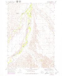
The Cheyenne River winds through this West River landscape, defining the jagged topography between Phiney Flat and a series of prominent elevated landforms known locally as tables. This 1954 survey, updated with 1970s revisions, shows the Chicago Milwaukee St Paul and Pacific railroad cutting across the northeastern corner, following the path of Spring Draw. The map documents a critical transition in the Black Hills periphery, where the rugged breaks of the river valley meet the flat, usable high ground of Kube Table and Hart Table. Significant drainage systems like Spring Creek and Indian Creek carve deep into the plateau, illustrating the erosional patterns characteristic of the Pennington and Custer county line. This map is particularly valuable for tracing historical land use and the original rail corridor through this sparsely settled territory.
Find a feature on this map
12 named features on this map. Tap any name to fly to it.
Don’t see what you’re looking for? This feature index may not catch every label — zoom into the map to look around manually.
Map Details
Editions of this 1954 Scenic SW Map
2 editions found
Other maps of this area

1950 · Sheep Mountain Table
USGS Topo · 1:24,000

1951 · Heutmacher Table
USGS Topo · 1:24,000

1951 · Red Shirt NE
USGS Topo · 1:24,000

1953 · Folsom
USGS Topo · 1:24,000

1953 · Caputa NE
USGS Topo · 1:24,000

1954 · Scenic
USGS Topo · 1:24,000

1954 · Creston
USGS Topo · 1:24,000

1954 · Scenic SW
USGS Topo · 1:24,000

1954 · Brennan Flat
USGS Topo · 1:24,000

1955 · Hot Springs
USGS Topo · 1:250,000