
1953 Map of Caputa NE
USGS Topo · Published 1955About this map
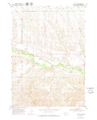
Rapid Creek meanders through the heart of this Pennington County landscape, defining the topography of the central valley just before the mid-century. The Chicago Milwaukee St Paul and Pacific railroad tracks parallel the water, indicating the vital transportation corridor that connected this rural stretch of South Dakota to larger markets. On the higher ground north of the creek, the Knuppe Sch serves as a small but significant landmark for local history and genealogy research. The southern portion of the map is dominated by the prominent elevations of the Railroad Buttes, while various drainages like Lindsey Draw and Elkhorn Draw carve through the terrain. Evidence of local industry is sparse but present, noted by a single Gravel Pit near the center of the survey area.
Find a feature on this map
8 named features on this map. Tap any name to fly to it.
Don’t see what you’re looking for? This feature index may not catch every label — zoom into the map to look around manually.
Map Details
Editions of this 1953 Caputa NE Map
2 editions found
Other maps of this area

1953 · New Underwood
USGS Topo · 1:24,000

1953 · New Underwood SW
USGS Topo · 1:24,000

1953 · Caputa
USGS Topo · 1:24,000

1953 · Folsom
USGS Topo · 1:24,000

1953 · Rapid City
USGS Topo · 1:250,000

1953 · Caputa SW
USGS Topo · 1:24,000

1954 · Creston
USGS Topo · 1:24,000

1954 · Scenic SW
USGS Topo · 1:24,000

1955 · Hot Springs
USGS Topo · 1:250,000

1957 · Rapid City
USGS Topo · 1:250,000