
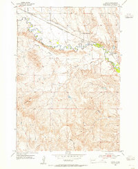
1953 Map of Caputa
USGS Topo · Published 1955About this map
Rapid Creek meanders across this Pennington County landscape, defining the northern geography of the area in the early 1950s. The Chicago Milwaukee St Paul and Pacific railroad runs parallel to the creek, serving the small settlements of Caputa and Farmingdale. This rail corridor and the associated Lone Tree Ditch highlight a period where water management and locomotive transport were central to rural South Dakota life. To the south, the terrain rises toward Thompson Butte, giving way to a network of seasonal watercourses including Antelope Creek, Lindsey Draw, and Indian Trail Draw. The presence of the Larsen Cem near Farmingdale provides a specific point of interest for those researching local family history or the early placement of community burial grounds relative to the floodplain.
Find a feature on this map
11 named features on this map. Tap any name to fly to it.
Don’t see what you’re looking for? This feature index may not catch every label — zoom into the map to look around manually.
Map Details
Editions of this 1953 Caputa Map
2 editions found
Other maps of this area

1893 · Rapid
USGS Topo · 1:125,000

1894 · Hermosa
USGS Topo · 1:125,000

1898 · Rapid
USGS Topo · 1:125,000

1901 · Hermosa
USGS Topo · 1:125,000

1903 · Rapid
USGS Topo · 1:125,000

1953 · Boxelder
USGS Topo · 1:24,000

1953 · New Underwood
USGS Topo · 1:24,000

1953 · New Underwood SW
USGS Topo · 1:24,000

1953 · Hermosa SE
USGS Topo · 1:24,000

1953 · Folsom
USGS Topo · 1:24,000