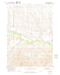
1953 Map of Caputa NE
USGS Topo · Published 1979About this map
Rapid Creek defines the central valley of this Pennington County landscape, where the Chicago Milwaukee St Paul and Pacific rail line follows the water’s edge through the plains. The terrain is marked by significant topographical features like Elkhorn Buttes and deep drainage systems such as Lindsey Draw and Railroad Draw. This 1953 survey, with purple revisions from 1976, captures the rural infrastructure of the mid-20th century, including the Knuppe Sch and a local Gravel Pit. The map shows a transition from the elevated tablelands near Underwood to the lower creek bottom, illustrating how early transportation corridors were dictated by the natural breaks in the South Dakota prairie.
Find a feature on this map
7 named features on this map. Tap any name to fly to it.
Don’t see what you’re looking for? This feature index may not catch every label — zoom into the map to look around manually.
Map Details
Editions of this 1953 Caputa NE Map
2 editions found
Other maps of this area

1953 · New Underwood
USGS Topo · 1:24,000

1953 · New Underwood SW
USGS Topo · 1:24,000

1953 · Caputa
USGS Topo · 1:24,000

1953 · Folsom
USGS Topo · 1:24,000

1953 · Caputa NE
USGS Topo · 1:24,000

1953 · Rapid City
USGS Topo · 1:250,000

1953 · Caputa SW
USGS Topo · 1:24,000

1954 · Creston
USGS Topo · 1:24,000

1954 · Scenic SW
USGS Topo · 1:24,000

1955 · Hot Springs
USGS Topo · 1:250,000