
1957 Map of Owanka NW
USGS Topo · Published 1958About this map
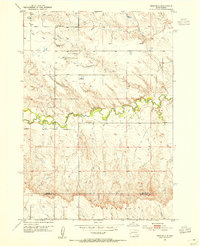
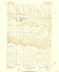
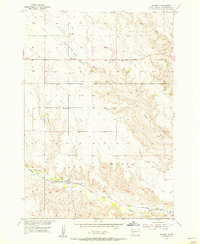
Elk Creek winds through the northern reaches of this mid-century prairie landscape, defining a terrain of draws and ridges where the high plains meet the edges of local settlement. The map documents a sparsely populated ranching and farming region on the border of Meade and Pennington Counties, characterized by small rural hubs and isolated landmarks. The settlement of Underwood anchors the southern portion of the sheet, while scattered educational sites like Schoun Sch and Lone Star Sch highlight the historical infrastructure of the township system before widespread school consolidation. Water management is central to life in this arid environment, evidenced by the presence of Tisdale Lake and the Vesta Dam on Patterson Creek, which support the livestock and agricultural operations around Lakeside and the Hoffman vicinity.
Find a feature on this map
11 named features on this map. Tap any name to fly to it.
Don’t see what you’re looking for? This feature index may not catch every label — zoom into the map to look around manually.
Map Details
Editions of this 1957 Owanka NW Map
This is the sole edition of this map. No revisions or reprints were ever made.
Other maps of this area
1953 · Viewfield
USGS Topo · 1:24,000

1953 · Hereford SE
USGS Topo · 1:24,000
1953 · New Underwood
USGS Topo · 1:24,000

1953 · Rapid City
USGS Topo · 1:250,000

1954 · Elm Springs SW
USGS Topo · 1:24,000
1954 · Owanka
USGS Topo · 1:24,000

1954 · Elm Springs
USGS Topo · 1:24,000

1957 · Rapid City
USGS Topo · 1:250,000

1957 · Owanka NE
USGS Topo · 1:24,000

1957 · Owanka SW
USGS Topo · 1:24,000