
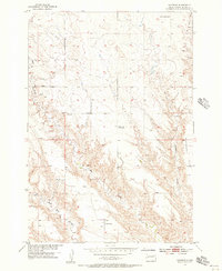
1954 Map of Boneita Springs
USGS Topo · Published 1958About this map
Belle Fourche River valley life in the mid-1950s is defined by its wide drainage basins and scattered rural infrastructure. The small settlement of Boneita Springs serves as a local anchor, supported by the Boneita Springs Sch and the nearby Boneita Springs Dam. This landscape is shaped by the erratic paths of West Bull Creek and Bull Creek, which carve through the high ground of Harwood Flat. Further west, the Hope Sch and the M Bar C Landing Field illustrate the practical necessities of education and transportation in this western South Dakota landscape. The presence of a Gravel Pit and the Spillway 2586 suggest localized engineering efforts to manage the water resources of the river basin during the post-war era.
Find a feature on this map
14 named features on this map. Tap any name to fly to it.
Don’t see what you’re looking for? This feature index may not catch every label — zoom into the map to look around manually.
Map Details
Editions of this 1954 Boneita Springs Map
This is the sole edition of this map. No revisions or reprints were ever made.
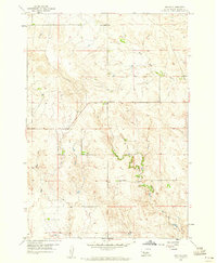
Other maps of this area

1953 · Rapid City
USGS Topo · 1:250,000

1954 · Dalzell NW
USGS Topo · 1:24,000

1954 · Elm Springs SW
USGS Topo · 1:24,000

1954 · Dalzell
USGS Topo · 1:24,000
1954 · Haydraw
USGS Topo · 1:24,000

1954 · Elm Springs
USGS Topo · 1:24,000

1957 · Rapid City
USGS Topo · 1:250,000
1959 · Enning
USGS Topo · 1:24,000

1959 · Union Center
USGS Topo · 1:24,000

1983 · Whiteman Owl
USGS Topo · 1:24,000