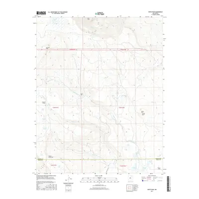
2017 Map of White Peak
USGS Topo · Published 2017About this map
White Vega and the nearby Mora Ranch occupy a high-elevation landscape defined by the rugged interface of mesas and mountain peaks along the Colfax Co Mora Co line. The terrain is marked by a complex hydrological network where drainages like Rayado Cr and Banderitas Cr flow from volcanic and tectonic features. Significant landmarks such as Crater Peak and La Grulla Ridge overlook a series of small, high-altitude water bodies including Rimrock Lake, Rose Lake, and Gardenia Lake. To the south and east, the land opens into expansive flat-topped features like White Peak Ortega Mesa and Laguna Salada Mesa. The survey details the remote cattle ranching and wilderness character of this region, reachable only by routes like Canada Bonita Rd through Franklin Canyon.
Find a feature on this map
36 named features on this map. Tap any name to fly to it.
Don’t see what you’re looking for? This feature index may not catch every label — zoom into the map to look around manually.
Map Details
Editions of this 2017 White Peak Map
This is the sole edition of this map. No revisions or reprints were ever made.
Other maps of this area

1954 · Raton
USGS Topo · 1:250,000

1956 · Tooth Of Time
USGS Topo · 1:62,500

1956 · Miami
USGS Topo · 1:62,500

1958 · Raton
USGS Topo · 1:250,000

1966 · Guadalupita
USGS Topo · 1:24,000

1966 · Mora Ranch
USGS Topo · 1:24,000

1966 · Ocate
USGS Topo · 1:24,000

1981 · Springer
USGS Topo · 1:100,000

1983 · Taos
USGS Topo · 1:100,000
1987 · Agua Fria Peak
USGS Topo · 1:24,000