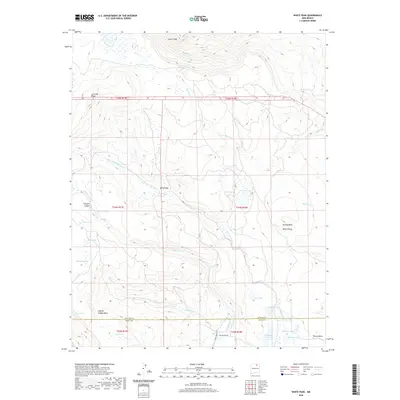
2020 Map of White Peak
USGS Topo · Published 2020About this map
White Peak stands as a prominent high point in this high-altitude landscape along the border of Colfax and Mora counties. The terrain is defined by a series of expansive mesas and ridges, including Laguna Salada Mesa, Ortega Mesa, and the northern La Grulla Ridge, which dictate the flow of numerous seasonal drainages like Rayado Cr and Moras Cr. This 2020 survey illustrates a complex hydrological network of small upland basins, where features like Rimrock Lake, Rose Lake, and Gardenia Lake collect snowmelt and runoff. The presence of Beaver Ponds along Wheaten Cr and several named springs, such as Lucero Spring, points to the vital water sources that have historically supported ranching and transit across this high-desert plateau. Sparse infrastructure like Whites Peak RD and Canada Bonita RD provides the primary access through the canyon systems and across open areas like White Vega.
Find a feature on this map
36 named features on this map. Tap any name to fly to it.
Don’t see what you’re looking for? This feature index may not catch every label — zoom into the map to look around manually.
Map Details
Editions of this 2020 White Peak Map
This is the sole edition of this map. No revisions or reprints were ever made.
Other maps of this area

1954 · Raton
USGS Topo · 1:250,000

1956 · Tooth Of Time
USGS Topo · 1:62,500

1956 · Miami
USGS Topo · 1:62,500

1958 · Raton
USGS Topo · 1:250,000

1966 · Guadalupita
USGS Topo · 1:24,000

1966 · Mora Ranch
USGS Topo · 1:24,000

1966 · Ocate
USGS Topo · 1:24,000

1981 · Springer
USGS Topo · 1:100,000

1983 · Taos
USGS Topo · 1:100,000
1987 · Agua Fria Peak
USGS Topo · 1:24,000