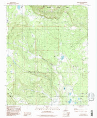
1994 Map of White Peak
USGS Topo · Published 1998About this map
Philmont Scout Ranch occupies the northern reaches of this high-altitude landscape, where the rugged topography of the Sangre de Cristo foothills meets the vast mesas of Colfax and Mora counties. The map captures a transition between the northern high peaks, like Crater Peak, and the rolling tablelands of Ortega Mesa. Settlement is sparse and largely focused on livestock operations, evidenced by several outpost sites including La Grulla Cow Camp, Martinez Cow Camp, and the Windmill Corral.
Find a feature on this map
43 named features on this map. Tap any name to fly to it.
Don’t see what you’re looking for? This feature index may not catch every label — zoom into the map to look around manually.
Map Details
Editions of this 1994 White Peak Map
This is the sole edition of this map. No revisions or reprints were ever made.
Other maps of this area

1954 · Raton
USGS Topo · 1:250,000

1956 · Tooth Of Time
USGS Topo · 1:62,500

1956 · Miami
USGS Topo · 1:62,500

1958 · Raton
USGS Topo · 1:250,000

1966 · Guadalupita
USGS Topo · 1:24,000

1966 · Mora Ranch
USGS Topo · 1:24,000

1966 · Ocate
USGS Topo · 1:24,000

1981 · Springer
USGS Topo · 1:100,000

1983 · Taos
USGS Topo · 1:100,000
1987 · Agua Fria Peak
USGS Topo · 1:24,000