1965 Map of White Pine
USGS Topo · Published 1973About this map
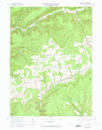
White Pine and the surrounding high country of Cogan House township appear here as a patchwork of upland clearings and dense woods. The landscape is defined by the headwaters of Larrys Creek and its many tributaries, such as Wendell Run and Buck Run, which have carved deep drainages into the plateau. In the mid-1960s, these small agricultural and timber-based communities maintained a quiet, rural character centered on local landmarks like Summit Ch and the Cogan House Sch. The map reveals the relationship between the rugged terrain and human settlement, with homesteads clustered in the flatter basins of Beech Grove and Steam Valley. Extensive woodland management is evident through the inclusion of State Game Lands No 75 and State Game Lands No 114, which border the dispersed settlements of Steuben and Buttonwood.
Find a feature on this map
49 named features on this map. Tap any name to fly to it.
Don’t see what you’re looking for? This feature index may not catch every label — zoom into the map to look around manually.
Map Details
Editions of this 1965 White Pine Map
3 editions found
Historical Maps of Steam Valley Through Time
52 maps found

1921 Trout Run
Lycoming County, PA

1923 Trout Run
Lycoming County, PA

1930 Warrensville
Lycoming County, PA

1934 Warrensville
Lycoming County, PA

1935 Waterville
Lycoming County, PA

1937 Waterville
Lycoming County, PA

1943 Waterville
Lycoming County, PA

1944 Trout Run
Lycoming County, PA

1946 Slate Run
Lycoming County, PA

1948 Slate Run
Lycoming County, PA

1953 Warrensville
Lycoming County, PA

1965 Barbours
Lycoming County, PA

1965 Bodines
Lycoming County, PA

1965 Cammal
Lycoming County, PA

1965 Cogan Station
Lycoming County, PA

1965 English Center
Lycoming County, PA

1965 Huntersville
Lycoming County, PA

1965 Jersey Mills
Lycoming County, PA

1965 Linden
Lycoming County, PA

1965 Montoursville North
Lycoming County, PA

1965 Montoursville South
Lycoming County, PA

1965 Trout Run
Lycoming County, PA

1965 Waterville
Lycoming County, PA

1965 White Pine
Lycoming County, PA

1969 Grover
Lycoming County, PA

1969 Ralston
Lycoming County, PA

1977 Ralston
Lycoming County, PA

1984 Williamsport East
Lycoming County, PA

1994 Cammal
Lycoming County, PA

1994 Cogan Station
Lycoming County, PA

1994 English Center
Lycoming County, PA

1994 Montoursville South
Lycoming County, PA

1994 Slate Run
Lycoming County, PA

1994 Waterville
Lycoming County, PA

1995 Barbours
Lycoming County, PA

1999 Montoursville North
Lycoming County, PA

2023 Barbours
Lycoming County, PA

2023 Bodines
Lycoming County, PA

2023 Cammal
Lycoming County, PA

2023 Cogan Station
Lycoming County, PA

2023 English Center
Lycoming County, PA

2023 Grover
Lycoming County, PA

2023 Huntersville
Lycoming County, PA

2023 Jersey Mills
Lycoming County, PA

2023 Linden
Lycoming County, PA

2023 Montoursville North
Lycoming County, PA

2023 Montoursville South
Lycoming County, PA

2023 Ralston
Lycoming County, PA

2023 Slate Run
Lycoming County, PA

2023 Trout Run
Lycoming County, PA

2023 Waterville
Lycoming County, PA

2023 White Pine
Lycoming County, PA
Featured Locations
- Jackson Township, PA
- Cogan House Township, PA
- Pine Township, PA
- Steam Valley, Cogan House Township
- White Pine, Cogan House Township