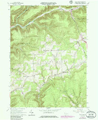
1965 Map of White Pine
USGS Topo · Published 1986About this map
White Pine and the surrounding township of Cogan House are defined by a network of steep hollows and narrow creek valleys during the mid-1960s. The landscape is structured by deep geographic drainages like Blacks Creek and Larrys Creek, which carved the rugged terrain of Pine and Cogan House. Settlement is concentrated along these valley floors and high ridgelines, where community life centered on the Summit Ch, the Cogan House Sch, and local burials at Persun Cem.
Find a feature on this map
43 named features on this map. Tap any name to fly to it.
Don’t see what you’re looking for? This feature index may not catch every label — zoom into the map to look around manually.
Map Details
Editions of this 1965 White Pine Map
3 editions found
Other maps of this area

1921 · Trout Run
USGS Topo · 1:62,500

1923 · Trout Run
USGS Topo · 1:62,500

1925 · Blossburg
USGS Topo · 1:62,500

1927 · Blossburg
USGS Topo · 1:62,500

1935 · Waterville
USGS Topo · 1:24,000

1937 · Waterville
USGS Topo · 1:48,000

1943 · Waterville
USGS Topo · 1:62,500

1944 · Blossburg
USGS Topo · 1:62,500

1944 · Trout Run
USGS Topo · 1:62,500

1946 · Antrim
USGS Topo · 1:62,500
Featured Places
- Steam Valley, Cogan House Township
- White Pine, Cogan House Township
- Cogan House Township, PA
- Pine Township, PA
- Jackson Township, PA