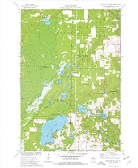
1973 Map of White Potato Lake
USGS Topo · Published 1977About this map
White Potato Lake and its surrounding wetlands anchor this 1973 survey of the borderlands between Marinette and Oconto Counties. The landscape is a dense network of glacial water bodies and marshes, including Gilas Lake, Nelligan Lake, and the complex Halfmoon Lake chain. Settlement patterns follow the grid of section lines, with the Brazeau Cem and Patz Landing Field serving as local markers in the township of Brazeau. The eastern portion is dominated by the Beaver Creek State Public Hunting Grounds, while the Peshtigo River cuts through the northeast corner near the Peshtigo Brook drainage. This survey reflects a mid-century period of recreation and conservation, showing numerous public access points and landings that highlight the area's transition from timber and pioneer farming toward a preserved water-based wilderness and hunting territory.
Find a feature on this map
52 named features on this map. Tap any name to fly to it.
Don’t see what you’re looking for? This feature index may not catch every label — zoom into the map to look around manually.
Map Details
Editions of this 1973 White Potato Lake Map
This is the sole edition of this map. No revisions or reprints were ever made.
Other maps of this area

1940 · Thunder Mtn.
USGS Topo · 1:48,000

1940 · Athelstane
USGS Topo · 1:48,000

1941 · Coleman
USGS Topo · 1:48,000

1942 · Athelstane
USGS Topo · 1:48,000

1942 · Coleman
USGS Topo · 1:48,000

1942 · Breed
USGS Topo · 1:48,000

1950 · Coleman
USGS Topo · 1:48,000

1951 · Thunder Mountain
USGS Topo · 1:48,000

1952 · Mountain
USGS Topo · 1:48,000

1954 · Iron Mountain
USGS Topo · 1:250,000