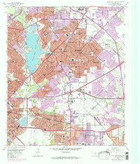
1958 Map of White Rock Lake
USGS Topo · Published 1974About this map
White Rock Lake serves as the focal point of this Eastern Dallas landscape, which captures a period of intense post-war suburban transformation. While the northwestern portions around the lake and Lakewood Country Club reflect established residential patterns, the purple-tinted revisions indicate the rapid eastward march of the city toward Mesquite and Garland. Notable institutional presence is found at the Buckner Orphans Home and numerous local schools like Adams High Sch and Reilly Sch, which speak to the area's mid-century population boom. Transportation networks define the region's development, from the veteran corridors of the Missouri Kansas Texas Railroad and Texas and Pacific Railroad to the newer Veterans World War II Memorial Highway. Infrastructure such as the Slack Pumping Plant and the Garland Airport reflect the utility and aviation history of this Dallas-area quadrangle.
Find a feature on this map
83 named features on this map. Tap any name to fly to it.
Don’t see what you’re looking for? This feature index may not catch every label — zoom into the map to look around manually.
Map Details
Editions of this 1958 White Rock Lake Map
2 editions found
Other maps of this area

1891 · Dallas
USGS Topo · 1:125,000

1893 · Dallas
USGS Topo · 1:125,000

1931 · Carrollton
USGS Topo · 1:62,500

1954 · Dallas
USGS Topo · 1:250,000

1957 · White Rock Lake
USGS Topo · 1:24,000

1958 · Dallas
USGS Topo · 1:250,000

1958 · Hutchins
USGS Topo · 1:24,000

1958 · Oak Cliff
USGS Topo · 1:24,000

1958 · Dallas
USGS Topo · 1:24,000

1958 · White Rock Lake
USGS Topo · 1:24,000