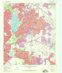
1957 Map of White Rock Lake
USGS Topo · Published 1969About this map
White Rock Lake and its surrounding neighborhoods dominate this mid-century portrait of northeast Dallas, just as suburban expansion began to accelerate toward Garland and Mesquite. The map documents a transitional period where established institutions like the Buckner Orphans Home and Grove Hill Memorial Park (Cemetery) sat alongside emerging infrastructure, including the White Rock Airport and the sprawling campus of Adams High Sch.
Find a feature on this map
92 named features on this map. Tap any name to fly to it.
Don’t see what you’re looking for? This feature index may not catch every label — zoom into the map to look around manually.
Map Details
Editions of this 1957 White Rock Lake Map
Other maps of this area

1891 · Dallas
USGS Topo · 1:125,000

1893 · Dallas
USGS Topo · 1:125,000

1931 · Carrollton
USGS Topo · 1:62,500

1954 · Dallas
USGS Topo · 1:250,000

1957 · White Rock Lake
USGS Topo · 1:24,000

1958 · Dallas
USGS Topo · 1:250,000

1958 · Hutchins
USGS Topo · 1:24,000

1958 · Oak Cliff
USGS Topo · 1:24,000

1958 · Dallas
USGS Topo · 1:24,000

1958 · White Rock Lake
USGS Topo · 1:24,000