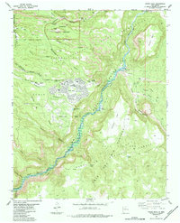
1984 Map of White Rock
USGS Topo · Published 1984About this map
Bandelier National Monument and the Sacred Area dominate the northwestern landscape, preserving a concentration of ancestral sites such as Duchess Castle (Ruins), Tsankawi Ruins, and the Navawi Ruins. This 1984 survey documents the expanding residential footprints of White Rock and Pajarito Acres perched above the deep gorge of White Rock Canyon. The Rio Grande flows through the center, feeding into the northern reaches of the Cochiti Reservoir. Local infrastructure of the era is marked by institutions like Chamisa Sch and Pinon Sch, while the Caja Del Rio Plateau to the east remains largely open, crisscrossed by a Jeep Trail and the visible path of an Old Railroad Grade near Buckman. This map captures the juxtaposition of modern scientific-community expansion alongside deeply significant archaeological landscapes.
Find a feature on this map
44 named features on this map. Tap any name to fly to it.
Don’t see what you’re looking for? This feature index may not catch every label — zoom into the map to look around manually.
Map Details
Editions of this 1984 White Rock Map
2 editions found
Other maps of this area

1892 · Santa Clara
USGS Topo · 1:125,000

1951 · Agua Fria
USGS Topo · 1:24,000

1952 · White Rock
USGS Topo · 1:24,000

1952 · Frijoles
USGS Topo · 1:24,000

1952 · Puye
USGS Topo · 1:24,000

1952 · Montoso Peak
USGS Topo · 1:24,000

1952 · Guaje Mountain
USGS Topo · 1:24,000

1953 · Espanola
USGS Topo · 1:24,000

1953 · Cochiti Dam
USGS Topo · 1:24,000

1953 · Horcado Ranch
USGS Topo · 1:24,000