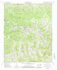
1960 Map of White Rocks Mountain
USGS Topo · Published 1988About this map
Roan Mountain serves as a central hub in this high-elevation landscape, where the Doe River cuts through steep ridges on its way toward the valley. The map documents a deeply established mountain community at the edge of the Cherokee National Forest, characterized by an extensive network of small family cemeteries and remote mountain churches like Bowling Chapel and Sugar Hollow Ch. The terrain is marked by significant gaps and knobs, including Vance Gap and the Heupscup Knobs, which dictate the winding paths of local roads and the placement of early settlements.
Find a feature on this map
95 named features on this map. Tap any name to fly to it.
Don’t see what you’re looking for? This feature index may not catch every label — zoom into the map to look around manually.
Map Details
Editions of this 1960 White Rocks Mountain Map
3 editions found
Other maps of this area

1891 · Roan Mountain
USGS Topo · 1:125,000

1893 · Cranberry
USGS Topo · 1:125,000

1894 · Roan Mountain
USGS Topo · 1:125,000

1895 · Cranberry
USGS Topo · 1:125,000

1899 · Cranberry
USGS Topo · 1:125,000

1902 · Cranberry
USGS Topo · 1:125,000

1904 · Roan Mountain
USGS Topo · 1:125,000

1934 · White Rocks Mtn
USGS Topo · 1:24,000

1934 · Bakersville
USGS Topo · 1:24,000

1934 · Iron Mtn Gap
USGS Topo · 1:24,000