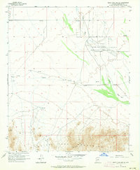
1957 Map of White Tank Mts. NE
USGS Topo · Published 1964About this map
Military aviation facilities and arid desert terrain define this mid-century view of the Arizona landscape west of Phoenix. The map is anchored by the landing strips of Luke Air Force Auxiliary Field No 1 and Luke Auxiliary Field No 4 (City of Phoenix), reflecting the era's significant defense footprint in Maricopa County. To the south, the topography rises sharply into the White Tank Mountains, where the desert floor gives way to steep ridges and narrow canyons. Historical evidence of early infrastructure is visible through a scattered network of Jeep Tr paths and several small water catchments simply labeled Reservoir. Evidence of local industry and engineering can be found at a small Quarry and a Tunnel located near the southern peaks. Drainage patterns across the alluvial plains are dominated by the winding course of Trilby Wash, which cuts across the territory from the northwest.
Find a feature on this map
14 named features on this map. Tap any name to fly to it.
Don’t see what you’re looking for? This feature index may not catch every label — zoom into the map to look around manually.
Map Details
Editions of this 1957 White Tank Mts. NE Map
4 editions found
Other maps of this area

1954 · Phoenix
USGS Topo · 1:250,000

1957 · Phoenix
USGS Topo · 1:250,000

1957 · White Tank Mts. SE
USGS Topo · 1:24,000

1957 · White Tank Mts. NE
USGS Topo · 1:24,000

1957 · McMicken Dam
USGS Topo · 1:24,000

1957 · Waddell
USGS Topo · 1:24,000

1957 · White Tank Mts.
USGS Topo · 1:62,500

1958 · Phoenix
USGS Topo · 1:250,000

1960 · Phoenix
USGS Topo · 1:250,000
1965 · Wittmann
USGS Topo · 1:24,000