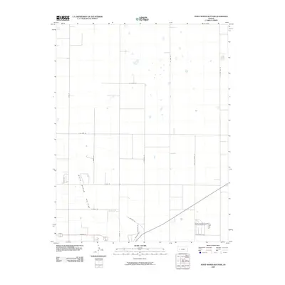
2009 Map of White Woman Bottoms
USGS Topo · Published 2009About this map
White Woman Bottoms characterizes the low-lying terrain of this Finney County landscape, reflecting the agricultural and ranching infrastructure of western Kansas in the early 21st century. The map reveals a strictly organized grid of rural corridors, including N Sixteen Mile Rd and N Farmland Rd, which serve the expansive agricultural parcels defining the region. A notable concentrated point of industrial activity is the Finney Company Feedyard Incorporated Airport in the southeastern quadrant, a facility that underscores the intersection of aviation and the local cattle industry. The presence of numerous small, ephemeral depressions or basins across the northern sections illustrates the natural drainage patterns inherent to this semi-arid environment, while named routes like Antelope Rd and Finney Co Feeders Rd facilitate the movement of livestock and goods through this specialized prairie landscape.
Find a feature on this map
18 named features on this map. Tap any name to fly to it.
Don’t see what you’re looking for? This feature index may not catch every label — zoom into the map to look around manually.
Map Details
Editions of this 2009 White Woman Bottoms Map
This is the sole edition of this map. No revisions or reprints were ever made.
Other maps of this area

1896 · Garden
USGS Topo · 1:125,000

1944 · Tennis
USGS Topo · 1:62,500

1955 · Dodge City
USGS Topo · 1:250,000

1955 · Scott City
USGS Topo · 1:250,000

1958 · Dodge City
USGS Topo · 1:250,000

1958 · Scott City
USGS Topo · 1:250,000

1959 · Dodge City
USGS Topo · 1:250,000

1960 · Garden City East
USGS Topo · 1:24,000
1960 · Garden City West
USGS Topo · 1:24,000

1967 · Pierceville
USGS Topo · 1:24,000