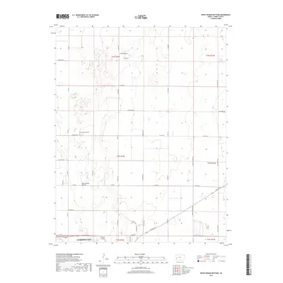
2018 Map of White Woman Bottoms
USGS Topo · Published 2018About this map
Garden City sits at the southern edge of this West Central Kansas landscape, where the urban grid of the county seat meets the expansive section-line agriculture of the High Plains. The terrain is defined by White Woman Bottoms, a distinctive geographic depression that historically received the ephemeral drainage of White Woman Creek. The map reveals a strictly organized rural network, with gravel and paved roads like Shoupe Rd and N Sixteen Mile Rd defining mile-square sections. A notable point for family historians is the Hulpieu Homestead Cem, located north of E Six Mile Rd, serving as a silent marker of early settlement efforts in Finney County. The transition from the developed outskirts of the city to the large-scale industrial farming operations to the north is evidenced by the numerous irrigation wells and feeders scattered throughout the bottoms.
Find a feature on this map
34 named features on this map. Tap any name to fly to it.
Don’t see what you’re looking for? This feature index may not catch every label — zoom into the map to look around manually.
Map Details
Editions of this 2018 White Woman Bottoms Map
This is the sole edition of this map. No revisions or reprints were ever made.
Other maps of this area

1896 · Garden
USGS Topo · 1:125,000

1944 · Tennis
USGS Topo · 1:62,500

1955 · Dodge City
USGS Topo · 1:250,000

1955 · Scott City
USGS Topo · 1:250,000

1958 · Dodge City
USGS Topo · 1:250,000

1958 · Scott City
USGS Topo · 1:250,000

1959 · Dodge City
USGS Topo · 1:250,000

1960 · Garden City East
USGS Topo · 1:24,000
1960 · Garden City West
USGS Topo · 1:24,000

1967 · Pierceville
USGS Topo · 1:24,000