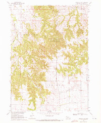
1969 Map of Whiteclay SW
USGS Topo · Published 1972About this map
Metcalf State Wildlife Management Area dominates the central portion of this Sheridan County landscape, where the broken terrain of the Beaver Wall escarpment drops toward the drainage of Beaver Creek. The topography reflects the transitional nature of the Nebraska Panhandle, moving from the dissected uplands near Bomar Hill in the northeast to the more open valleys of the south. This late 1960s survey documents the rural character of the region, showing the winding course of Hay Springs Creek and White Clay Creek. For the local historian or genealogist, the map preserves specific cultural markers such as the Episcopal Cem and a smaller Cem located near the eastern boundary, alongside utilitarian features like the Gravel Pit that supported local road infrastructure during this period of development in the Missouri River Basin.
Find a feature on this map
14 named features on this map. Tap any name to fly to it.
Don’t see what you’re looking for? This feature index may not catch every label — zoom into the map to look around manually.
Map Details
Editions of this 1969 Whiteclay SW Map
This is the sole edition of this map. No revisions or reprints were ever made.
Other maps of this area

1955 · Alliance
USGS Topo · 1:250,000

1957 · Alliance
USGS Topo · 1:250,000

1958 · Alliance
USGS Topo · 1:250,000

1966 · Hay Springs NE
USGS Topo · 1:24,000

1966 · Hay Springs
USGS Topo · 1:24,000

1966 · Chadron 3 NE
USGS Topo · 1:24,000

1969 · Whiteclay
USGS Topo · 1:24,000

1969 · Beaver Wall
USGS Topo · 1:24,000

1969 · Chadron NE
USGS Topo · 1:24,000

1969 · Bordeaux
USGS Topo · 1:24,000