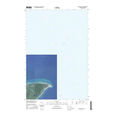
2017 Map of Whitefish Point
USGS Topo · Published 2017About this map
Whitefish Point serves as a critical maritime landmark where the southern expanse of Lake Superior meets the protected waters of Whitefish Bay. This 2017 survey details the immediate peninsula, dominated by a mix of wetlands and shoreline infrastructure at the end of N Whitefish Point Rd. The interior landscape is defined by the transitions between township sections like t50n r5w and t51n r6w, with a sparse road network including W Wild Cat Rd and W N Shore Rd cutting through the coastal terrain. Genealogists and local historians will find the Whispering Pines Cem located west of the point along W Cemetery Rd, serving the small community at this prominent Upper Peninsula geographic turn.
Find a feature on this map
14 named features on this map. Tap any name to fly to it.
Don’t see what you’re looking for? This feature index may not catch every label — zoom into the map to look around manually.
Map Details
Editions of this 2017 Whitefish Point Map
This is the sole edition of this map. No revisions or reprints were ever made.
Other maps of this area

1951 · Vermilion SE
USGS Topo · 1:24,000

1951 · Shelldrake
USGS Topo · 1:24,000

1951 · Whitefish Point
USGS Topo · 1:24,000

1951 · Shelldrake
USGS Topo · 1:62,500

1954 · Sault Sainte Marie
USGS Topo · 1:250,000

1956 · Sault Sainte Marie
USGS Topo · 1:250,000

1957 · Sault Sainte Marie
USGS Topo · 1:250,000

1958 · Sault Sainte Marie
USGS Topo · 1:250,000
1985 · Two Hearted River
USGS Topo · 1:100,000
1985 · Sault Ste. Marie North
USGS Topo · 1:100,000