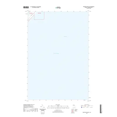
2019 Map of Whitefish Point OE S
USGS Topo · Published 2019About this map
Lake Superior dominates this nautical landscape, showing the open waters of the lake and the sheltered expanse of Whitefish Bay. In this 2019 survey, the coastline is barely visible in the upper-left corner, where N Whitefish Point Rd provides a small corridor of land-based access to the shoreline. The map focuses almost entirely on the aquatic geography of the Upper Peninsula, specifically the waters southeast of Whitefish Point. The lack of terrestrial features highlights the isolation of this stretch of Michigan’s coastline, where maritime routes were historically more significant than inland roads. The boundary lines for t50n r6w and t50n r5w indicate the offshore extension of local township divisions over the lake's surface.
Find a feature on this map
5 named features on this map. Tap any name to fly to it.
Don’t see what you’re looking for? This feature index may not catch every label — zoom into the map to look around manually.
Map Details
Editions of this 2019 Whitefish Point OE S Map
This is the sole edition of this map. No revisions or reprints were ever made.
Other maps of this area

1951 · Vermilion SE
USGS Topo · 1:24,000

1951 · Shelldrake
USGS Topo · 1:24,000

1951 · Emerson
USGS Topo · 1:24,000

1951 · Whitefish Point
USGS Topo · 1:24,000

1951 · Shelldrake
USGS Topo · 1:62,500

1954 · Sault Sainte Marie
USGS Topo · 1:250,000

1956 · Sault Sainte Marie
USGS Topo · 1:250,000

1957 · Sault Sainte Marie
USGS Topo · 1:250,000

1958 · Sault Sainte Marie
USGS Topo · 1:250,000
1985 · Two Hearted River
USGS Topo · 1:100,000