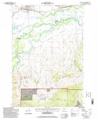
1996 Map of Whitehall
USGS Topo · Published 1998About this map
The town of Whitehall serves as the focal point for this landscape, where the confluence of Whitetail Creek and Pipestone Creek meets the wide meanders of the Jefferson River. The topography transitions from the agricultural flats of Parrot Bench, supported by the Parrot Ditch, to the northern reaches of the Tobacco Root Mountains. This area is defined by a historical legacy of extraction, visible in the numerous mines and prospects scattered across Gold Hill and near Mayflower Gulch. Further south, the map details the rugged boundary of the Deerlodge National Forest, where high-elevation landmarks like Point of Rocks overlook the Westphal Basin. Genealogy researchers will find value in the location of the Whitehall Cemetery and smaller outlying locales like Renova and Piedmont. Local recreation is anchored by the Parrot Castle Fishing Access, while the complex drainage network includes features like Slough and Dry Lake.
Find a feature on this map
45 named features on this map. Tap any name to fly to it.
Don’t see what you’re looking for? This feature index may not catch every label — zoom into the map to look around manually.
Map Details
Editions of this 1996 Whitehall Map
This is the sole edition of this map. No revisions or reprints were ever made.
Other maps of this area

1888 · Three Forks
USGS Topo · 1:250,000

1893 · Dillon
USGS Topo · 1:250,000

1894 · Three Forks
USGS Topo · 1:250,000

1895 · Three Forks
USGS Topo · 1:250,000

1947 · Bozeman
USGS Topo · 1:250,000

1948 · Bozeman
USGS Topo · 1:250,000

1950 · Jefferson Island
USGS Topo · 1:62,500

1950 · Harrison
USGS Topo · 1:62,500

1955 · Bozeman
USGS Topo · 1:250,000

1955 · Dillon
USGS Topo · 1:250,000
Featured Places
- Whitehall, MT
- La Casa Trailer Park, Whitehall
- Rice Motel and Trailer Court, Whitehall
- Madison County, MT
- Jefferson County, MT