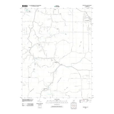
2010 Map of Whitehall
USGS Topo · Published 2010About this map
The settlement of Ellettsville anchors the northeastern corner of this Monroe County landscape, where the flat upland of Louden Ridge gives way to a network of winding creek valleys and named hollows. This area is characterized by small rural communities like Whitehall and Hendricksville, which are connected by a dense grid of county roads such as W Vernal Pike and W Howard Rd. The terrain is deeply inscribed with family and local history, evident in the numerous burial grounds including Moreland Cemetery, Hopewell Cemetery, and Gross Cemetery that dot the countryside. Water systems define the local geography, from Richland Creek flowing through the central valley to Timber Ridge Lake and its associated dam in the north. The southern reaches of the map feature distinctive landforms like Blair Hollow and Green Ham Hollow, illustrating the diverse topography that shaped early Indiana farmsteads and rural development.
Find a feature on this map
71 named features on this map. Tap any name to fly to it.
Don’t see what you’re looking for? This feature index may not catch every label — zoom into the map to look around manually.
Map Details
Editions of this 2010 Whitehall Map
This is the sole edition of this map. No revisions or reprints were ever made.
Other maps of this area

1908 · Bloomington
USGS Topo · 1:48,000

1908 · Bloomfield
USGS Topo · 1:62,500

1910 · Bloomington
USGS Topo · 1:62,500

1947 · Gosport
USGS Topo · 1:24,000

1950 · Gosport
USGS Topo · 1:24,000

1953 · Indianapolis
USGS Topo · 1:250,000

1956 · Indianapolis
USGS Topo · 1:250,000
1956 · Clear Creek
USGS Topo · 1:24,000

1956 · Freedom
USGS Topo · 1:24,000
1956 · Bloomington
USGS Topo · 1:24,000