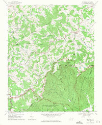
1968 Map of Whitehead
USGS Topo · Published 1971About this map
The high ridges of the Blue Ridge Mountains define this 1968 survey of the border between Alleghany and Wilkes counties. Much of the southern landscape is preserved within the Doughton Recreation Area and the Thurmond Chatham Wildlife Management Area, featuring landmarks such as the Brinegar Cabin and the Caudill Cabin. The Blue Ridge Parkway winds along the crest, passing several scenic points including Alligator Back and Bluff Mountain.
Find a feature on this map
61 named features on this map. Tap any name to fly to it.
Don’t see what you’re looking for? This feature index may not catch every label — zoom into the map to look around manually.
Map Details
Editions of this 1968 Whitehead Map
This is the sole edition of this map. No revisions or reprints were ever made.
Other maps of this area

1889 · Wytheville
USGS Topo · 1:125,000

1889 · Wilkesboro
USGS Topo · 1:125,000

1891 · Wilkesboro
USGS Topo · 1:125,000

1892 · Wytheville
USGS Topo · 1:125,000

1930 · Independence
USGS Topo · 1:48,000

1933 · Independence
USGS Topo · 1:62,500

1935 · Mouth of Wilson
USGS Topo · 1:48,000

1940 · Mouth of Wilson
USGS Topo · 1:62,500

1953 · Winston-Salem
USGS Topo · 1:250,000

1955 · Winston-Salem
USGS Topo · 1:250,000