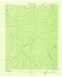
1933 Map of Whiteoak Flats
USGS Topo · Published 1933About this map
The Unicoi Mountains and the winding course of Citico Creek dominate this 1933 survey, produced by the Tennessee Valley Authority as an advance sheet. This rugged section of the Tennessee-North Carolina boundary is largely defined by the early administrative divisions of the Cherokee National Forest and the Nantahala National Forest. While much of the terrain is a dense network of ridges and hollows, evidence of small Appalachian communities remains visible at Jeffrey and near the Tallassee School.
Find a feature on this map
48 named features on this map. Tap any name to fly to it.
Don’t see what you’re looking for? This feature index may not catch every label — zoom into the map to look around manually.
Map Details
Editions of this 1933 Whiteoak Flats Map
This is the sole edition of this map. No revisions or reprints were ever made.
Other maps of this area

1886 · Knoxville
USGS Topo · 1:125,000

1892 · Knoxville
USGS Topo · 1:125,000

1893 · Murphy
USGS Topo · 1:125,000

1894 · Knoxville
USGS Topo · 1:125,000

1895 · Loudon
USGS Topo · 1:125,000

1895 · Knoxville
USGS Topo · 1:125,000

1901 · Knoxville
USGS Topo · 1:125,000

1914 · Murphy
USGS Topo · 1:125,000

1927 · Big Junction
USGS Topo · 1:24,000
1933 · Haw Knob
USGS Topo · 1:48,000