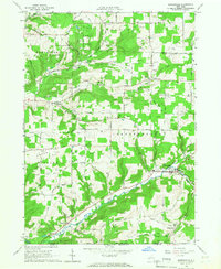
1965 Map of Whitesville
USGS Topo · Published 1966About this map
The Genesee River cuts through the southwest corner of this region, where the town of Paynesville sits along the Cryder Creek valley. In the mid-1960s, this portion of Allegany County was a landscape defined by industrial extraction and rural settlements. Extensive gas and oil fields dominate the high ground of the Independence and Andover townships, with dozens of active wells connected by a network of pipelines and service roads like Pipeline Road.
Find a feature on this map
69 named features on this map. Tap any name to fly to it.
Don’t see what you’re looking for? This feature index may not catch every label — zoom into the map to look around manually.
Map Details
Editions of this 1965 Whitesville Map
2 editions found
Other maps of this area

1899 · Gaines
USGS Topo · 1:62,500

1900 · Gaines
USGS Topo · 1:62,500

1926 · Wellsville
USGS Topo · 1:62,500

1926 · Greenwood
USGS Topo · 1:62,500

1932 · Genesee
USGS Topo · 1:62,500

1937 · Genesee
USGS Topo · 1:62,500

1950 · Elmira
USGS Topo · 1:250,000

1954 · Williamsport
USGS Topo · 1:250,000
1957 · Harrison Valley
USGS Topo · 1:24,000

1958 · Elmira
USGS Topo · 1:250,000