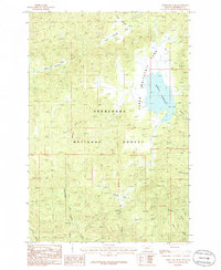
1985 Map of Whitetail Peak
USGS Topo · Published 1986About this map
Deerlodge National Forest dominates this mountain landscape in Jefferson County, defined by the high elevations of Whitetail Peak and the surrounding wilderness. The eastern portion of the sheet is centered on the expansive Whitetail Reservoir, which serves as a major hydrological hub for local drainages like Whitetail Creek and Spring Creek. The terrain is marked by a legacy of resource exploration, indicated by numerous Prospect and Prospects notations scattered throughout the peaks, along with a specific Mine Shaft located west of the reservoir.
Find a feature on this map
20 named features on this map. Tap any name to fly to it.
Don’t see what you’re looking for? This feature index may not catch every label — zoom into the map to look around manually.
Map Details
Editions of this 1985 Whitetail Peak Map
This is the sole edition of this map. No revisions or reprints were ever made.
Other maps of this area

1889 · Helena
USGS Topo · 1:250,000

1893 · Helena
USGS Topo · 1:250,000

1893 · Dillon
USGS Topo · 1:250,000

1899 · Boulder
USGS Topo · 1:125,000

1899 · Helena
USGS Topo · 1:250,000

1903 · Helena
USGS Topo · 1:250,000

1947 · Butte
USGS Topo · 1:250,000

1954 · Elk Park
USGS Topo · 1:62,500

1954 · Boulder
USGS Topo · 1:62,500

1955 · Dillon
USGS Topo · 1:250,000