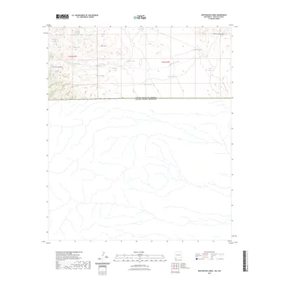
2023 Map of Whitewater Creek
USGS Topo · Published 2023About this map
The San Luis Mountains and the Whitewater Mountains anchor this arid landscape along the international border between the United States of America and Mexico. The terrain is defined by a critical network of water management features, including numerous livestock tanks named for early ranchers and local figures, such as Dick Bass Tank, Chavez Tank, and Edwards Tank. These features represent the essential infrastructure of rangeland history in the Animas Valley region of New Mexico. The drainage patterns of Been Draw and Whitewater Creek illustrate the natural flow of water through this high-desert environment, while named points like Prospector Tank hint at the area's legacy of resource exploration. This map captures the remote character of the borderlands where topography and water rights dictate the human footprint.
Find a feature on this map
19 named features on this map. Tap any name to fly to it.
Don’t see what you’re looking for? This feature index may not catch every label — zoom into the map to look around manually.
Map Details
Editions of this 2023 Whitewater Creek Map
This is the sole edition of this map. No revisions or reprints were ever made.
Other maps of this area

1917 · Antelope Wells
USGS Topo · 1:62,500

1918 · Cienega Springs
USGS Topo · 1:62,500

1919 · Antelope Wells
USGS Topo · 1:62,500

1955 · Douglas
USGS Topo · 1:250,000

1959 · Douglas
USGS Topo · 1:250,000

1961 · Douglas
USGS Topo · 1:250,000

1964 · Douglas
USGS Topo · 1:250,000
1982 · Fitzpatricks
USGS Topo · 1:24,000
1982 · Hilo Peak
USGS Topo · 1:24,000
1982 · San Luis Pass
USGS Topo · 1:24,000