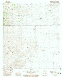
1983 Map of Whitewater Creek
USGS Topo · Published 1983About this map
The Continental Divide runs through the high desert of Hidalgo County in this 1983 survey, crossing the San Luis Mountains along the border between the United States and Mexico. This international boundary separates New Mexico from Chihuahua, where the topography transitions into the Sierra San Luis. The landscape is defined by an extensive network of water management features, including numerous named stock tanks such as Prospector Tank, Nations Tank, and McKinney Tank scattered across the arid terrain.
Find a feature on this map
31 named features on this map. Tap any name to fly to it.
Don’t see what you’re looking for? This feature index may not catch every label — zoom into the map to look around manually.
Map Details
Editions of this 1983 Whitewater Creek Map
This is the sole edition of this map. No revisions or reprints were ever made.
Other maps of this area

1917 · Antelope Wells
USGS Topo · 1:62,500

1918 · Cienega Springs
USGS Topo · 1:62,500

1919 · Antelope Wells
USGS Topo · 1:62,500

1955 · Douglas
USGS Topo · 1:250,000

1959 · Douglas
USGS Topo · 1:250,000

1961 · Douglas
USGS Topo · 1:250,000

1964 · Douglas
USGS Topo · 1:250,000
1982 · Fitzpatricks
USGS Topo · 1:24,000
1982 · Hilo Peak
USGS Topo · 1:24,000
1982 · San Luis Pass
USGS Topo · 1:24,000