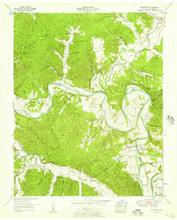
1952 Map of Whitfield
USGS Topo · Published 1957About this map
The Duck River carves a winding path through this portion of Hickman County, defining a landscape of deep horseshoe bends and fertile bottomlands. In the mid-twentieth century, the settlement of Whitfield served as a local hub near the southern edge of the survey, surrounded by a network of family cemeteries and rural institutions. Significant river crossings and landmarks like Huddleston Bridge and the Gaging station near the confluence with the Piney River illustrate the importance of these waterways to local transit and management.
Find a feature on this map
97 named features on this map. Tap any name to fly to it.
Don’t see what you’re looking for? This feature index may not catch every label — zoom into the map to look around manually.
Map Details
Editions of this 1952 Whitfield Map
2 editions found
Other maps of this area

1901 · Colombia
USGS Topo · 1:125,000

1936 · Pleasantville
USGS Topo · 1:24,000

1936 · Coble
USGS Topo · 1:24,000

1936 · Beaverdam Springs
USGS Topo · 1:24,000

1936 · Nunnelly
USGS Topo · 1:24,000

1936 · Whitfield
USGS Topo · 1:24,000

1936 · Sunrise
USGS Topo · 1:24,000

1936 · Bucksnort
USGS Topo · 1:24,000

1936 · Texas Hollow
USGS Topo · 1:24,000

1936 · Spot
USGS Topo · 1:24,000