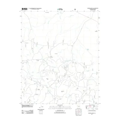
2011 Map of Whiting Knoll
USGS Topo · Published 2011About this map
Whiting Knoll rises above a high-elevation landscape in Apache County, defined by a network of ranching homesteads and vital water sources at the start of the 21st century. The map centers on the Whiting Homestead and Halls Ranch, connected by a web of forest service roads including FS RD 117 and FS RD 404. This region is characterized by its numerous developed water features, critical for livestock in the arid Southwest, such as Halls Tank Number One, Crossbred Tank, and Little Giant Tank.
Find a feature on this map
65 named features on this map. Tap any name to fly to it.
Don’t see what you’re looking for? This feature index may not catch every label — zoom into the map to look around manually.
Map Details
Editions of this 2011 Whiting Knoll Map
This is the sole edition of this map. No revisions or reprints were ever made.
Other maps of this area

1886 · St Johns
USGS Topo · 1:250,000

1892 · St Johns
USGS Topo · 1:250,000

1954 · Saint Johns
USGS Topo · 1:250,000

1957 · Saint Johns
USGS Topo · 1:250,000

1958 · Saint Johns
USGS Topo · 1:250,000

1962 · Saint Johns
USGS Topo · 1:250,000

1968 · Boundary Butte
USGS Topo · 1:24,000

1968 · Springerville NW
USGS Topo · 1:24,000

1969 · Whiting Knoll
USGS Topo · 1:24,000
1969 · Greer
USGS Topo · 1:24,000