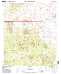
1997 Map of Whiting Knoll
USGS Topo · Published 2000About this map
High-altitude ranching and timber landscapes of the Apache National Forest define this 1997 topographic record. Central to the sheet is the Whiting Knoll and the nearby Whiting Homestead, representing the area's legacy of high-country settlement. The terrain is marked by volcanic features like Cerro Trigo, Cerro Montosa, and Saint Peters Dome, while a network of springs and tanks, including Kitchen Spring and Hutcherson Spring, underscores the critical importance of water management in this arid environment. Evidence of local land use is seen at the Halls Ranch and Aspen Meadows Ranch to the southeast. Industrial activity is noted by a Cinder Pit and several Gravel Pit locations, supporting the road network that connects these remote points through Mallory Draw and the Potato Patch.
Find a feature on this map
62 named features on this map. Tap any name to fly to it.
Don’t see what you’re looking for? This feature index may not catch every label — zoom into the map to look around manually.
Map Details
Editions of this 1997 Whiting Knoll Map
This is the sole edition of this map. No revisions or reprints were ever made.
Other maps of this area

1886 · St Johns
USGS Topo · 1:250,000

1892 · St Johns
USGS Topo · 1:250,000

1954 · Saint Johns
USGS Topo · 1:250,000

1957 · Saint Johns
USGS Topo · 1:250,000

1958 · Saint Johns
USGS Topo · 1:250,000

1962 · Saint Johns
USGS Topo · 1:250,000

1968 · Boundary Butte
USGS Topo · 1:24,000

1968 · Springerville NW
USGS Topo · 1:24,000

1969 · Whiting Knoll
USGS Topo · 1:24,000
1969 · Greer
USGS Topo · 1:24,000