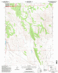
1993 Map of Whitinger Mountain
USGS Topo · Published 1996About this map
Whitinger Mountain dominates the center of this high-elevation landscape, where the northern evergreen reaches of the Modoc National Forest meet the broad, arid stretches of the Madeline Plains. The terrain is defined by dramatic volcanic and tectonic features, including the prominent South Knob and the long, sloping reaches of Dry Valley Ridge. Water is a scarce and precious resource in this environment, represented by isolated points like Bath Spring and the Said Valley Reservoir. The presence of a Cinder Pit and various Pit labels suggests the importance of volcanic material extraction in this part of Lassen County. A network of 4wd tracks provides the primary access through the steep drainages of Spooner Canyon and across the floor of Grasshopper Valley.
Find a feature on this map
20 named features on this map. Tap any name to fly to it.
Don’t see what you’re looking for? This feature index may not catch every label — zoom into the map to look around manually.
Map Details
Editions of this 1993 Whitinger Mountain Map
This is the sole edition of this map. No revisions or reprints were ever made.
Other maps of this area

1886 · Alturas
USGS Topo · 1:250,000

1886 · Honey Lake
USGS Topo · 1:250,000

1891 · Honey Lake
USGS Topo · 1:250,000

1892 · Alturas
USGS Topo · 1:250,000

1893 · Honey Lake
USGS Topo · 1:250,000

1954 · Grasshopper Valley
USGS Topo · 1:62,500

1954 · Alturas
USGS Topo · 1:250,000

1955 · Westwood
USGS Topo · 1:250,000

1956 · Hayden Hill
USGS Topo · 1:62,500

1958 · Alturas
USGS Topo · 1:250,000