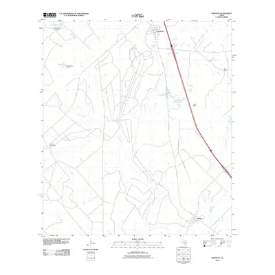
2010 Map of Whitsett
USGS Topo · Published 2010About this map
Campbellton sits at the northern edge of this South Texas landscape, where the Atascosa River and its numerous tributaries define the drainage of the region. The map reveals a land characterized by large-scale ranching and water management, evidenced by the extensive Seventy-Four Ranch and Tom Ranch properties. These holdings are marked by engineered water features such as 74 Ranch Dam Number 4 and Tom Ranch Lake Number 2, which are vital for livestock in this semi-arid environment. The topography rises into the Lipan Hills to the east, overlooking the confluence of Lipan Creek and the river valley. To the south, the settlement of Whitsett serves as a local hub near the crossing of Olmos Creek, connected by a network of state and county roads including US Hwy 281 Alt and FM 99. The intricate web of private ranch roads like Edmund Tom Ranch Rd illustrates the localized infrastructure of the modern Texas ranching economy.
Find a feature on this map
25 named features on this map. Tap any name to fly to it.
Don’t see what you’re looking for? This feature index may not catch every label — zoom into the map to look around manually.
Map Details
Editions of this 2010 Whitsett Map
This is the sole edition of this map. No revisions or reprints were ever made.
Other maps of this area

1925 · Crowther No. 3
USGS Topo · 1:48,000

1930 · Whitsett
USGS Topo · 1:62,500

1931 · Falls City
USGS Topo · 1:62,500

1942 · Whitsett
USGS Topo · 1:62,500

1953 · Crystal City
USGS Topo · 1:250,000

1955 · Crystal City
USGS Topo · 1:250,000

1956 · Suniland
USGS Topo · 1:62,500

1956 · Pleasanton
USGS Topo · 1:62,500

1961 · Crystal City
USGS Topo · 1:250,000
1961 · Fashing
USGS Topo · 1:24,000