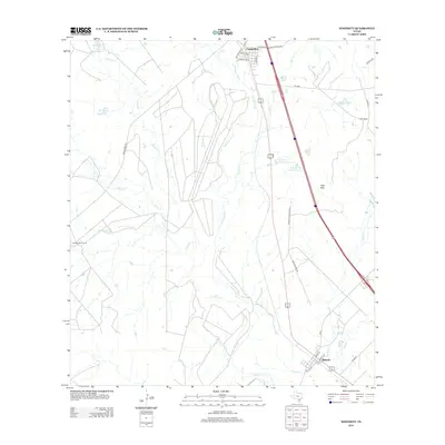
2012 Map of Whitsett
USGS Topo · Published 2012About this map
Campbellton and Whitsett anchor this South Texas landscape where the Atascosa River and its various tributaries, such as Metate Cr and La Parita Cr, define the drainage patterns of the region. The map reveals a land structured by long-standing ranching operations, including the Seventy-Four Ranch and the extensive Tom Ranch, the latter of which features several named water bodies like Tom Ranch Lake Number 1. This era shows a network of farm-to-market roads and local ranch routes, such as Edmund Tom Ranch Rd, facilitating movement between these rural hubs and the elevated Lipan Hills in the east. The settlement of Whitsett is detailed with its local street grid, including Main St and Womack St, illustrating the concentrated residential pocket near the convergence of Olmos Cr and Salt Br.
Find a feature on this map
33 named features on this map. Tap any name to fly to it.
Don’t see what you’re looking for? This feature index may not catch every label — zoom into the map to look around manually.
Map Details
Editions of this 2012 Whitsett Map
This is the sole edition of this map. No revisions or reprints were ever made.
Other maps of this area

1925 · Crowther No. 3
USGS Topo · 1:48,000

1930 · Whitsett
USGS Topo · 1:62,500

1931 · Falls City
USGS Topo · 1:62,500

1942 · Whitsett
USGS Topo · 1:62,500

1953 · Crystal City
USGS Topo · 1:250,000

1955 · Crystal City
USGS Topo · 1:250,000

1956 · Suniland
USGS Topo · 1:62,500

1956 · Pleasanton
USGS Topo · 1:62,500

1961 · Crystal City
USGS Topo · 1:250,000
1961 · Fashing
USGS Topo · 1:24,000